


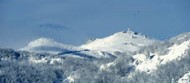
The Risnjak National Park is located in Gorski kotar, the most wooded part of western Croatia. It lies between latitude 45°24′ and 45°32′ north and longitude 14°33’30” and 14°43’30” east, in the immediate vicinity of the Adriatic Sea, only 15 km north-east from Rijeka. The Park covers an area of 63,5 km2 including the central part of the Risnjak and Snježnik massif, as well as the upper flow of the river Kupa with its source area. The area of the Risnjak massif was proclaimed a national park in 1953, at the suggestion of an eminent Croatian natural scientist and researcher of Risnjak, prof. dr. Ivo Horvat. Early in 1997, the NP “Risnjak” was extended to the area of the Snježnik massif and the source area of the river Kupa, thus fulfilling the wish of prof. dr. Ivo Horvat to protect and enhance this area. The area of the NP “Risnjak” belongs to the Dinaric mountain system which stretches from the eastern Alps to the Sar-Pindos Mountains, so that is a part of the area which connects the Alps and the Dinarides. Although large migrations of Alpine, arctic and boreal species moved across the Risnjak and Snježnik massif towards southeast, on these mountains a vegetation substantially different from the one in the Alps has been preserved. Due to various climatic, geologic, petrographic and other factors, a very heterogeneous flora and fauna has been preserved in this area. The Park is made mostly of limestone and dolomite with major karst features (karren on bare rocks, rock falls, doline/sinkholes, ponor/swallow holes, caves etc.). Therefore, in spite of great amounts of rain and snow in this area, in the Risnjak and Snježnik massif there are only very few weak springs (Klupice in Smrekovac and Studenac in Javorov kal), and the three permanent springs in Leska make a small stream which sinks through a ponor towards the source of the river Kupa which is located in the northeastern part of the Park and which represents a distinguished hydro-geological feature of this area. The source itself is an oval pond drawn underneath vertical rocks, some 50 m wide. The researches made so far have shown that the water springs out of two separate vertical channels. The narrower channel is 86 m deep, and the wider one 57 m. In the first few hundred meters of its flow, the river Kupa receives water from two torrent-streams, krašičevica and sušica, which at times bring great amounts of water and material through their wild canyons. The whole area of the river Kupa is rich in permanent and periodical streams which vary in size and intensity. The highest peak of the NP “Risnjak” – Veliki Risnjak – is only 1528 m high, but this massif together with the contiguous Snježnik massif (1506 m) is nevertheless a great climatic and vegetational barrier between coastal and continental parts of Croatia. Climatic influences from the Adriatic Sea penetrating from the nearby Kvarner bay and the continental influences penetrating through the Kupa valley collide here and play a significant role in determining the specific climate of the NP “Risnjak” with pleasantly warm summers and an average temperature up to 20°C, rainy springs an autums, and long, cold snowy winters. At the Risnjak mountain lodge, snow lies for full five months, sometimes up to 4 m deep.